

13 Major Himalayan Peaks You Will Spot on the Langtang Valley
The Langtang Valley Trek offers trekkers unique access to a high-concentration cluster of Himalayas. Navigating this landscape requires more than just endurance; it requires the ability to identify the massive rock and ice formations that define the northern and southern skylines. From the towering 7,227-meter summit of Langtang Lirung to the technical “alpine-style” faces of Naya Kanga, each peak serves as a critical geographic marker and cultural anchor for the indigenous Tamang community.
This guide provides the specific elevations, physical features, directional orientations, and descriptive photos necessary to recognize these summits from key vantage points like Kyanjin Ri (4,770m) and Tserko Ri (4,985m). Use the following profiles to master peak identification and understand the spiritual and environmental significance of the Langtang Himal.
Table of Contents
Langtang Lirung (Ghonne)
Langtang Lirung, locally known as Ghonne, dominates the Langtang Valley skyline at a precise elevation of 7,227 meters. The indigenous Tamang community reveres Langtang Lirung as a sacred guardian deity that protects the local villages and the region’s spiritual heritage. The mountain features a sheer vertical relief that rises dramatically above the valley floor, supporting a sprawling, active icefall that continuously shapes the moraines below.

Trekkers can identify Langtang Lirung by locating the tallest, most prominent peak towering over the northern sky above Kyanjin Gompa. Langtang Lirung distinguishes itself from neighboring Himalayan peaks through its massive, highly fractured eastern icefall and near-vertical rock faces.
The summits of Kyanjin Ri (4,773 meters) and Tserko Ri (4,984 meters) provide the most unobstructed, panoramic views of Langtang Lirung. Directional Orientation for Trekkers:
- From Tserko Ri: When standing on the summit of Tserko Ri, Langtang Lirung commands the western horizon.
- From Kyanjin Ri: From the Kyanjin Ri viewpoint, Langtang Lirung towers directly to the northwest.
Langtang II (Ghenge Liru)
Langtang II, officially known as Ghenge Liru, reaches an elevation of 6,596 meters within the Langtang National Park. The Tamang people of the Langtang Valley consider Ghenge Liru, alongside its neighboring peaks, as part of a sacred mountain amphitheater that feeds the region’s extensive glacier systems. The mountain features heavily glaciated slopes and forms a massive mountain wall that shapes the western ridges of the valley near the Tibetan border.
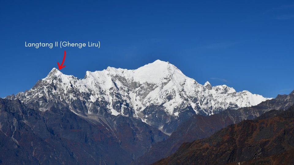
Trekkers can identify Langtang II by its unique, snake-like ridgeline that winds across the western horizon. While the taller Langtang Lirung dominates the northern sky, Langtang II sits exactly four kilometers to the west.
Trekkers can best observe Langtang II from the following specific locations:
- Langtang Village: This settlement offers the clearest, most direct views of the mountain’s southern face and its distinct snake-like ridgeline.
- Bus Journey to Syabrubesi: Travelers can spot the peak during the approach to Syabrubesi. For an unobstructed view, passengers should choose a seat by the right-side window.
Langtang II remains hidden from the upper valley viewpoints. The massive bulk of Langtang Lirung completely obstructs the line of sight to Langtang II from the following locations:
- Kyanjin Gompa
- Tserko Ri (4,984m)
- Kyanjin Ri (4,773m)
Yala Peak
Yala Peak has an altitude of 5,520 meters within the Langtang Himal range. Classified as a “trekking peak” by the Nepal Mountaineering Association, Yala Peak serves as the primary introductory summit for climbers due to its non-technical, walk-up terrain. The mountain features a relatively flat, snow-covered summit ridge and lacks the jagged rock faces common to the neighboring 7,000-meter giants.

Trekkers can identify Yala Peak by looking for the rounded, snowy dome located directly northern side of the Tserko Ri viewpoint. Yala Peak appears as a gentle, white slope that leads toward the Tibetan border.
The summit of Tserko Ri (4,984m) offers the most intimate, close-up views of Yala Peak. Trekkers also obtain clear sightlines from the high-altitude pastures of Yala Kharka, where the mountain’s southern flank is fully visible.
Directional Orientation for Trekkers
- From Tserko Ri: Yala Peak sits to the northern side.
- From Kyanjin Ri: Yala Peak is positioned to the northeast.
Langshisha Ri
Langshisha Ri reaches an elevation of 6,427 meters and marks the eastern boundary of the Langtang Valley. Unlike the rounded slopes of nearby trekking peaks, Langshisha Ri features sharp, jagged rock towers and steep glacial walls. The mountain serves as a critical geographic marker for the high-altitude pass leading toward the Panch Pokhari and Helambu regions.

Trekkers can identify Langshisha Ri by its distinct, pointed twin summits that dominate the head of the valley. Langshisha Ri is characterized by its dark, vertical rock faces and its position at the very end of the main Langtang glacier. It sits in between Pemthang Karpo Ri and Dorje Lakpa
The summit of Tserko Ri (4,984m) offers the most expansive view of the peak’s entire western face. For a closer perspective, hikers can trek to Langshisha Kharka, the high-altitude pasture located directly at the base of the mountain, where the rock towers appear most dramatic.
Directional Orientation for Trekkers
- From Tserko Ri: Langshisha Ri is located directly to the east.
- From Kyanjin Ri: Langshisha Ri is not visible from Kyanjin Ri.
Dorje Lakpa
Dorje Lakpa reaches an altitude of 6,966 meters and serves as a majestic boundary marker between the Langtang Valley and the Jugal Himal range. The mountain features a striking, near-perfect pyramid shape, covered in permanent snow and ice. Local communities and trekkers often describe Dorje Lakpa as one of the most aesthetically balanced peaks in the Central Himalayas.
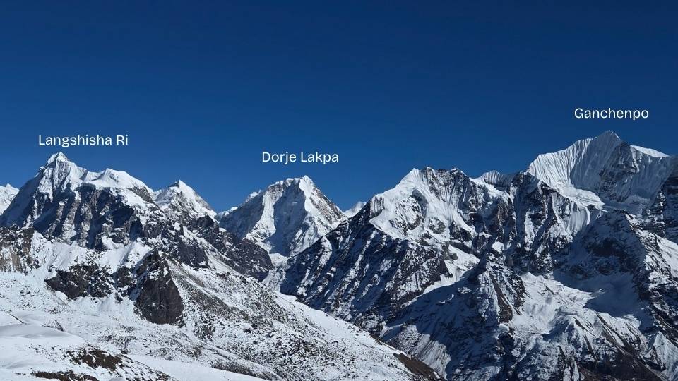
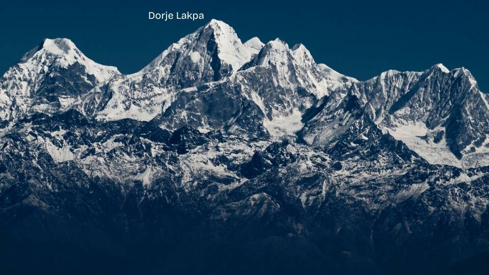
Trekkers can identify Dorje Lakpa by searching for the sharp, symmetrical white pyramid that stands at the far eastern end of the Langtang range. Dorje Lakpa maintains a distinct, pointed summit that remains visible even from great distances as one moves deeper into the valley.
The summit of Tserko Ri (4,984m) provides the most comprehensive and unobstructed view of Dorje Lakpa’s western face. Trekkers can also enjoy clear sightlines of the mountain from the high-altitude pastures of Langshisha Kharka, where its massive pyramid shape dominates the eastern horizon.
Directional Orientation for Trekkers
- From Tserko Ri: Dorje Lakpa is located directly to the east.
- From Kyanjin Ri: Dorje Lakpa is not visible from Kyanjin Ri.
Ganchenpo
Ganchenpo, often referred to by its descriptive name “The Fluted Peak,” rises to an elevation of 6,387 meters. Located at the southern edge of the Langtang region, Ganchenpo serves as a magnificent snowy divider between the Langtang and Helambu valleys. The mountain features unique, vertical snow flutings that run down its steep northern face, creating a distinct ribbed texture that sets it apart from the smoother granite walls of the range.

Trekkers can identify Ganchenpo by its sharp, symmetrical triangular shape and the prominent vertical ridges of snow and ice on its face. While the nearby Langshisha Ri appears dark and rocky, Ganchenpo remains consistently white and brilliantly reflective, standing as a bright sentinel at the head of the valley.
The summit of Tserko Ri (4,984m) provides the most comprehensive and direct sightlines of Ganchenpo’s northern flutings. Trekkers can view it from both Kyanjin Gompa and Langshisha Kharka on a clear day.
Directional Orientation for Trekkers
- From Tserko Ri: Ganchenpo is positioned directly to the southeast.
- From Kyanjin Ri: Ganchenpo lies toward the southeast.
- From Kyanjin Gompa: Ganchenpo lies toward the southeast.
Pangen Dopku
Pangen Dopku stands at an elevation of approximately 5,930 meters, forming a significant part of the high-altitude ridgeline that borders the Langtang Valley to the east. The mountain features a rugged, rocky summit often draped in seasonal snow. Local mountain guides recognize Pangen Dopku as a key landmark for navigating the upper glacial moraines leading toward the Tilman Pass.
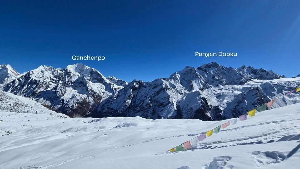
Trekkers can identify Pangen Dopku by locating the sharp, dark rock spire situated between the snowy massifs of Ganchenpo and Naya Kanga. Pangen Dopku is characterized by its steep vertical rock faces and its position overlooking the vast Kyanjin Gompa pastures.
Trekkers can enjoy good views from Kyanjin Gompa Valley, Tserko Ri, and Kyanjin Ri.
Directional Orientation for Trekkers
- From Tserko Ri: Pangen Dopku is positioned to the southeast.
- From Kyanjin Ri: Pangen Dopku lies toward the southeast.
- From Kyanjin Gompa: Pangen Dopku lies toward the southeast.
Naya Kanga
Naya Kanga, also known as Ganja La Chuli, rises to an altitude of 5,844 meters. The mountain features a steep, icy north face and a prominent ridgeline that leads toward the challenging Ganja La Pass. Mountaineers value Naya Kanga as a technical “alpine-style” climb that provides a transition from high-altitude trekking to technical peak climbing.
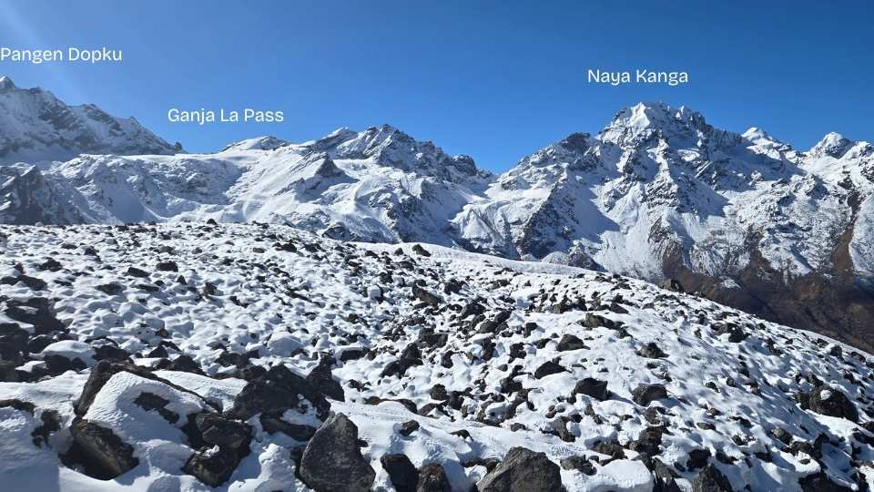
Trekkers can identify Naya Kanga by looking for the high, snow-draped summit directly across the valley from Kyanjin Gompa. It is the most dominant peak on the southern skyline when facing away from the Langtang Lirung massif.
The summit of Kyanjin Ri (4,773m) offers the most direct and dramatic head-on view of Naya Kanga’s northern glaciers. Trekkers also gain excellent perspective from the Tserko Ri (4,984m) summit, which reveals the mountain’s connection to the broader southern ridge and the Ganja La Pass.
Directional Orientation for Trekkers
- From Tserko Ri: Naya Kanga is positioned to the southwest.
- From Kyanjin Ri: Naya Kanga lies directly to the south.
- From Kyanjin Gompa: Naya Kanga lies directly to the south.
Baden Powell Scout Peak
Baden Powell Scout Peak, formerly known as Urkema Peak, has an elevation of 5,890 meters. Located along the high southern ridge of the Langtang Valley, the mountain was renamed in 2007 to honor the centenary of the Scouting movement. The peak features a distinct mushroom-shaped snow summit and a moderately steep glacier on its northern flank, making it a popular “climbing peak” for those transitioning from trekking to technical mountaineering.

Trekkers can identify Baden Powell Scout Peak by looking for the prominent, rounded snow dome situated directly west of Naya Kanga. Baden Powell Scout Peak is distinguished by its smoother, convex snow slopes and its position as the last major high point on the southern skyline before the valley turns toward the lower forest zones.
The summit of Kyanjin Ri (4,773m) offers an exceptional, head-on view of the mountain’s glaciated north face.
Directional Orientation for Trekkers
- From Tserko Ri: Baden Powell Scout Peak is positioned to the southwest.
- From Kyanjin Ri: Baden Powell Scout Peak lies to the southwest.
Other Notable Peaks of Lantang Valley
Kingshung and Yubra Peaks
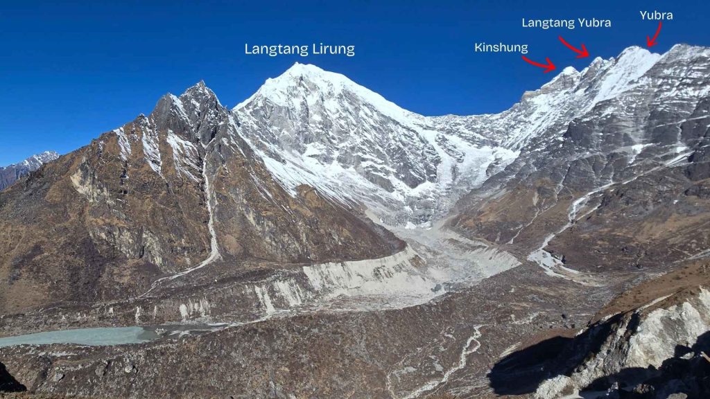
The Kingshung (6,011m), Langtang Yubra (6,035m), and Yubra (6,264m) peaks form a distinctive high-altitude cluster within the Langtang Himal. These three summits are positioned directly to the east of the Langtang Lirung massif. The peaks feature a unique, symmetrical alignment that resembles a massive mountain trident, with all three summits standing adjacent to one another along a continuous glacial ridge.
These three peaks can be clearly seen from Kyanjin Ri.
Dagpache
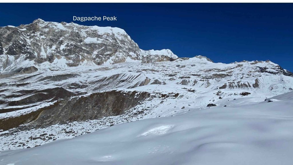
Dagpache rises to a precise altitude of 6,565 meters. Positioned on the northern side of Tserko Ri, the mountain features a distinct, flat-top summit rather than a traditional pointed peak structure. This broad, level plateau distinguishes Dagpache from the sharp, jagged rock towers found elsewhere in the Langtang Himal.
Conclusion: Mastering Peak Identification in Langtang
Identifying the major Himalayan peaks of the Langtang Valley transforms a high-altitude trek into a structured mountaineering study. By moving beyond general observations and focusing on specific markers such as the 7,227-meter vertical relief of Langtang Lirung or the trident-shaped alignment of the Yubra cluster trekkers can accurately navigate the complex topography of the Langtang Himal.
Whether you are observing the snake-like ridgeline of Langtang II from Langtang Village or tracking the pyramid silhouette of Dorje Lakpa from the Tserko Ri summit (4,985m), understanding these directional orientations ensures a deeper connection to the landscape. These summits are more than just background scenery; they are sacred cultural guardians for the local Tamang people and critical geographic sentinels for Himalayan navigation. Use this guide to enhance your spatial awareness and expertise during your journey through one of Nepal’s most visually diverse glacial valleys.


