
Syabrubesi: Before and After the Flood, History and Geography
Syabrubesi is one of the mountain towns in Langtang Valley and Rasuwa District. It is the main starting and ending point to the Langtang Valley, Tamang Heritage Trail and several other trekking routes. It sits in a narrow Bhotekoshi river corridor at roughly 1,460 metres/4,790 feet above sea level.
Syabrubesi was among the affected settlements, when on 26 August 2026, a major ice-rock avalanche and subsequent flood in the upper Lhende–Bhote Koshi river travelled downstream. It destroyed about 70% of Syabrubesi town. The route connecting Syabrubesi with Dhunche and the wider Kathmandu road network was disrupted. By late September, reconstruction was underway, but normal road access had not yet been fully restored to Syabrubesi.
Syabrubesi Before and After the Flood
Syabrubesi Before the 2026 Bhotekoshi Flood
Before the 2026 flood, Syabrubesi was a busy mountain settlement along the Bhote Koshi River in Rasuwa District. The village had limited flat land because steep mountains surround the river valley. Houses, shops, roads and other infrastructure were built on the available land above the river.
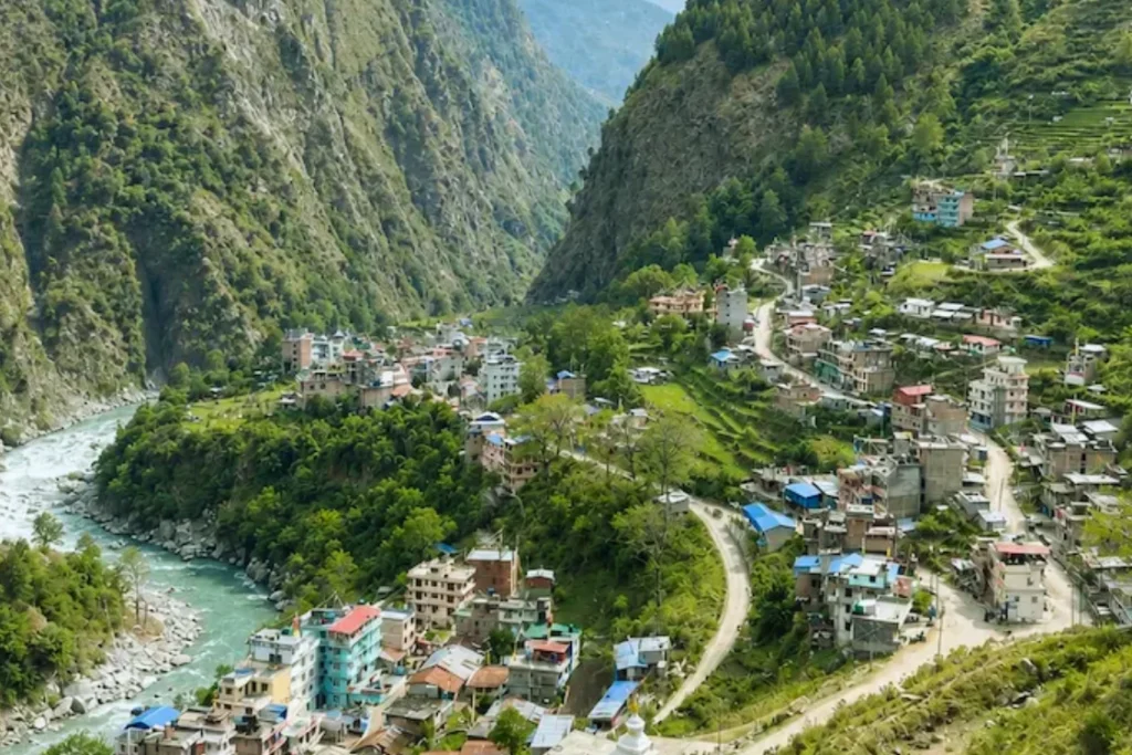
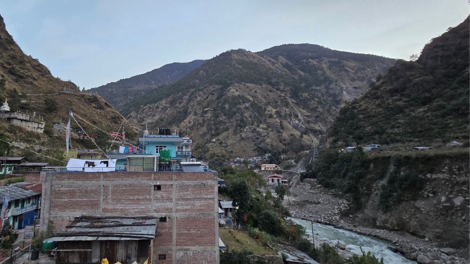
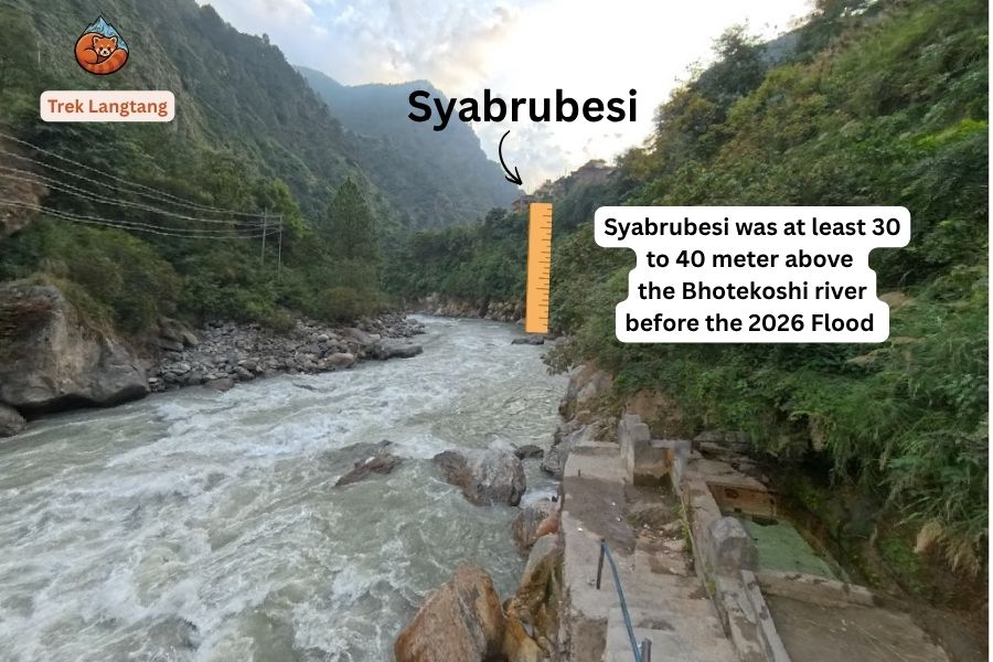
However, there was an important feature of Syabrubesi’s geography that made residents feel relatively safe from flooding. Much of the main settlement stood approximately 30 to 40 metres above the Bhote Koshi River. For generations, the river flowed well below the village, and there was little reason to believe that its water could suddenly rise high enough to reach the settlement. Before the disaster, if you had asked a long-time villager about the possibility of a major flood reaching the main village, the answer would likely have been that there was almost no chance.
Syabrubesi had also become an important local centre for tourism, transport and trade. Syabrubesi was the main road gateway to the Langtang Valley, where trekkers arrived from Kathmandu before starting their trek. Hotels, guesthouses, restaurants, shops and transport services supported both trekkers and local communities farther north.
Syabrubesi After the Flood
The flood of 26 August 2026 changed Syabrubesi’s landscape and its relationship with the Bhote Koshi River. The event was far larger than the floods normally experienced in the region. A huge volume of water, rock, mud and debris moved downstream through the river corridor and reached areas that had previously been considered relatively safe.
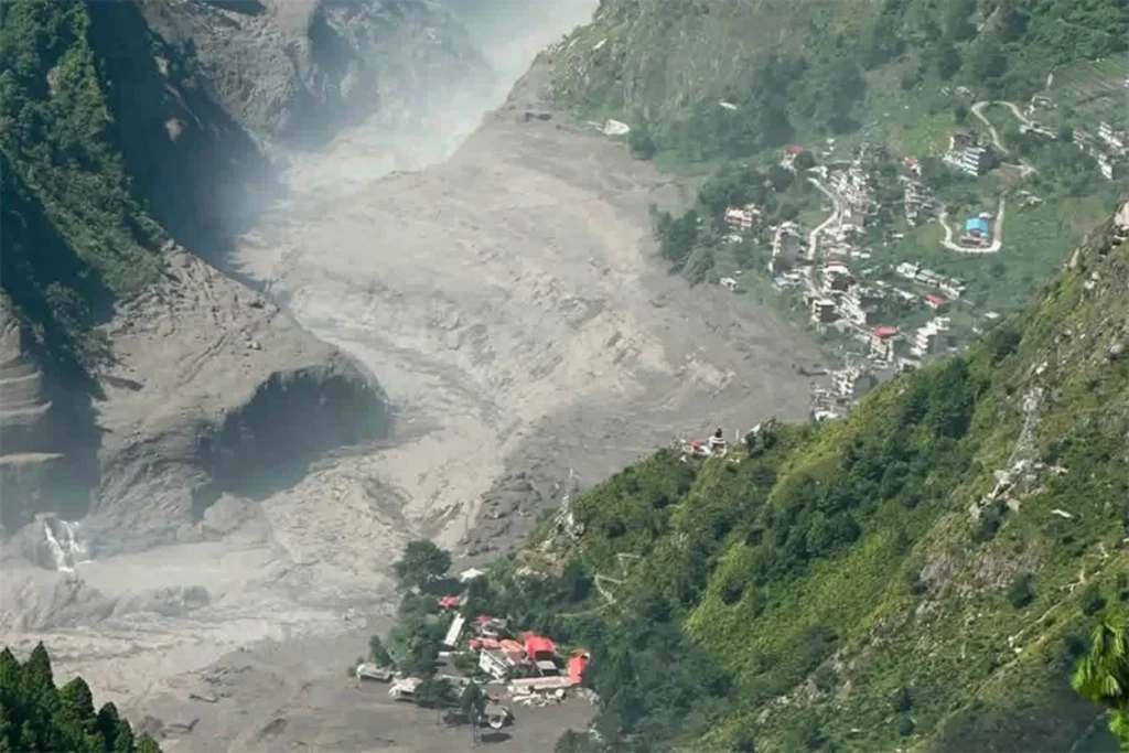
The lower part of Syabrubesi, closer to the Bhote Koshi River, suffered the most damage. Local estimates suggest that around 70% of the lower settlement was destroyed or seriously affected. Houses, shops, roads, bridges and other infrastructure were damaged or swept away.
The damage was not limited to Syabrubesi. The flood also affected Timure and Rasuwagadhi farther north, damaging roads, bridges, public infrastructure and hydropower facilities. The disaster disrupted the important road connection between Syabrubesi, Rasuwagadhi and the Nepal–China border.
Flood Timeline
The 2026 event is best understood as a cascading mountain disaster and Himalayan Tsunami rather than an ordinary monsoon flood.
Bhotekoshi Flood: Event Timeline
From the mountain breakoff down through the river valley to Syabrubesi
Water Speed Change: Extreme speeds at the steep cliff collapse slowed as the valley opened up.
1. Mountain Breakoff
High up on the mountain ridge, a massive slab of frozen rock, ice, and glacier debris broke loose from the cliff. Falling thousands of meters down a narrow chute, it hit the river headwaters at an extreme speed of 185 km/h, instantly pushing a violent wall of water, mud, and boulders downstream.
- Millions of tons of rock and ice collapsed from the high mountain ridge.
- The fall created the highest speed of the entire event (185 km/h).
- High-altitude river and weather sensors were crushed immediately upon impact.
2. Reached Rasuwagadhi
About 45 minutes after the mountain broke off, the surging muddy river smashed into the Nepal-China border at Rasuwagadhi. The narrow riverbed could not hold the sudden rush of water, tearing into customs yards and border crossings.
- Miteri Bridge connecting Nepal and China suffered heavy structural damage.
- Customs offices and the container truck parking yard were completely flooded.
- Hydropower intake tunnels were jammed by heavy boulders and mud.
3. Reached Timure
Twenty minutes later, the flood pounded Timure. Because houses, shops, and cargo trucks were parked along the tight riverbank, the sudden overflow caused extensive damage before water could drain downstream.
- Large cargo shipping trucks were overturned and washed down the river.
- Border police station buildings and roadside shops were submerged in mud.
- Key sections of the Pasang Lhamu Highway collapsed into the water.
4. Reached Syabrubesi
The flood arrived at Syabrubesi with its speed reduced down to 45 km/h as the valley widened. Quick warnings sent from up the river gave local residents precious minutes to run up the hills to safe ground.
- Walking suspension bridges across the river were broken and carried away.
- Riverside trekking lodges, camps, and fields suffered heavy mud damage.
- The widening valley allowed the wave to calm down to 45 km/h.
Quick Timeline Summary
A side-by-side comparison of the 4 checkpoints as the flood traveled downstream.
| Checkpoint | Arrival Time | Water Speed | River Height | What Took Place |
|---|---|---|---|---|
| 1. Mountain Breakoff | ~8:00 AM | 185 km/h | Avalanche burst | Rock & ice broke from high cliffs |
| 2. Rasuwagadhi | ~8:45 AM | ~95 km/h | Rose 8 to 12 meters | Hit border post & damaged Miteri Bridge |
| 3. Timure | ~9:05 AM | ~65 km/h | Rose 7 to 10 meters | Cargo trucks washed away & highway torn |
| 4. Syabrubesi | ~9:20 AM | 45 km/h in down | Rose 6 to 9 meters | Walking bridges broken; people fled uphill |
On the morning of 26 August, a large mass of rock and glacier detached in the high-altitude Lirung massif near the upper Lhende catchment. Satellite-based assessments indicate that the failed mass was roughly 1 to 1.3 kilometres across and descended into the river system, mobilising additional sediment and water. The resulting blockage and failure produced an exceptionally powerful flood that entered the Lhende and then the Bhote Koshi system.
The flood reached the Rasuwagadhi area very quickly and then travelled downstream through the Bhote Koshi and Trishuli corridors. Syabrubesi, Timure and other settlements were affected in the process. The exact mechanism was initially uncertain, with early reports discussing a possible glacial lake outburst, but later technical assessments increasingly identified an ice-rock avalanche and temporary river blockage as the major process.
Infrastructure Damage
The flood exposed how dependent northern Rasuwa is on a small number of bridges and road corridors.
The Pasang Lhamu Highway is the major road connection through this part of Rasuwa. Before the disaster, vehicles could travel from Kathmandu through Trishuli and Dhunche toward Syabrubesi and farther north toward Timure and Rasuwagadhi. After the flood, multiple sections were washed away or buried, and bridges became major bottlenecks.

The Department of Roads reported that 41 motorable bridges were destroyed between Rasuwa and Dhading during the disaster. In Syabrubesi itself, the bridge over the Bhote Koshi was washed away, making even local movement more difficult.
Further north, the approximately 15-kilometre road from Syabrubesi toward Rasuwagadhi was severely damaged. The damage also affected Nepal-China connectivity and the route to Gyirong, also commonly called Kerung in Nepal.
The flood also affected hydropower infrastructure. The Rasuwagadhi Hydropower Project, which has an installed capacity of 111 MW, was among the major projects affected by floods in the corridor. Earlier, the 2025 flood had also damaged Rasuwagadhi, Chilime and Upper Trishuli infrastructure.
Post-Flood Reconstruction, Recovery, and Local News Updates
Recovery in Syabrubesi is happening in stages rather than through one large reconstruction project.
By September 2026, temporary pedestrian infrastructure had already been introduced around some damaged sections. At Syabrubesi, a steel zipline was installed to help people cross where the concrete bridge had been destroyed, while temporary footbridges and other structures were being used elsewhere on the Rasuwa–Nuwakot route.
The larger challenge is restoring continuous vehicle access. As of 22 September, the Department of Roads said it was working to bring the Galchhi to Syabrubesi road into operation by Dashain, around mid-October. Repairs had progressed on several sections, but Bailey bridges were still required at Betrawati and Syabrubesi.
The northern section is a separate problem. The Syabrubesi to Rasuwagadhi road was reported as extensively damaged, and authorities had started surveying the route for reconstruction. The government was also seeking cooperation from China for restoration toward the Rasuwagadhi to Gyirong border.
For visitors, this means that an article saying simply “Syabrubesi is closed” or “Syabrubesi is open” can be misleading. Access changes as temporary tracks and bridges are completed and the monsoon may as well damage the roads again after it is build. The practical question is whether continuous, safe vehicle access exists on the exact date of travel.
Geographical Location of Syabrubesi
Syabrubesi lies in Rasuwa District of Bagmati Province, in north-central Nepal. Administratively, the settlement is associated with Gosainkunda Rural Municipality. The municipality itself has its administrative office at Syabrubesi, while Dhunche remains the headquarters of Rasuwa District.
Geographically, Syabrubesi is positioned between the lower hills around Dhunche and the higher Himalayan terrain of the Langtang region. This gives it an unusual character: it is low enough to have relatively warm, green surroundings, but it is already firmly within the mountain environment.
River Systems: Junction of Bhote Koshi River and Lhende Khola
The river system is central to understanding both Syabrubesi's geography and its flood risk.
The Bhote Koshi River forms the major river corridor through northern Rasuwa. Syabrubesi developed alongside this corridor because water, transport routes and settlement space all converge in the same narrow valley.
The Lhende Khola is farther north, around the Rasuwagadhi and Nepal-China border area. It joins the Bhote Koshi after passing through the border corridor. This distinction matters because the 2026 August flood originated much farther upstream than Syabrubesi but then travelled rapidly into the Bhote Koshi system.
The steep valley sides make the geography particularly sensitive to sudden changes in river flow. There is little room between the river and mountain slopes, so roads, bridges, hydropower structures and houses often occupy the same narrow corridor. When the river rises dramatically, infrastructure along this corridor can be affected at the same time.
Strategic Role as the Gateway Village to the Langtang Valley Trek
Syabrubesi is best known among international visitors as the gateway to the Langtang Valley Trek.
In normal conditions, trekkers travel from Kathmandu through Trishuli and Dhunche to Syabrubesi, stay overnight, and begin walking toward Lama Hotel and the upper Langtang Valley. The village also serves the Tamang Heritage Trail and other local trekking routes.
This role makes Syabrubesi more than just another village on a highway. It is a logistical transition point between road travel and trekking. Trekkers arrange accommodation, food, porters, guides and final supplies here before entering the higher mountains.
The 2026 flood demonstrated how dependent the entire Langtang tourism system is on this gateway. Even where the higher trekking trails were not directly destroyed, the loss of roads and bridges around Syabrubesi could isolate the valley from the normal transport network.
History of Syabrubesi
Syabrubesi’s history is closely connected with the Tamang communities of Rasuwa and the long-standing trade routes between Nepal and Tibet. For centuries, this part of the region served as a trans-Himalayan trade and cultural exchange zone, linking communities on both sides of the Himalayas.
The route from Syabrubesi through Rasuwagadhi toward Gyirong, also known as Kerung, in Tibet was historically used by traders, travellers and local communities. Goods such as salt, wool and agricultural products passed through this corridor before reaching the Nepal side at Rasuwagadhi. Over time, the traditional trade route evolved into a modern road corridor connecting Kathmandu with the Chinese border.
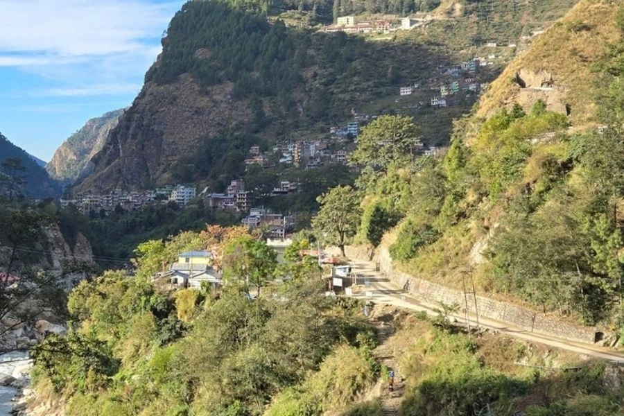
Syabrubesi itself was once a small settlement that mainly served merchants and travellers moving between Nepal and Tibet. At that time, many local families preferred to live in villages higher up the hills, such as Thulosyabru and Khamjing, while maintaining agricultural fields around the Syabrubesi area. The settlement was therefore closely connected with both mountain villages and the trading route below.
The character of Syabrubesi gradually changed as trekking became more established in the Langtang region. With more trekkers travelling through the area, accommodation, shops, restaurants and other services began to develop. Many families from the upper villages eventually moved down to Syabrubesi and settled there permanently. What was once a small settlement along an old trade route gradually developed into the busy gateway to the Langtang Valley and one of the main service centres of northern Rasuwa.
Practical Travel Information and Local Infrastructure
Road Accessibility, Transit Routes, and Bus Services
In normal conditions, the principal approach to Syabrubesi is from Kathmandu through the Trishuli and Dhunche corridor, using the Pasang Lhamu Highway and connected road sections.
The 2026 flood changed this significantly. As of late September, repairs had restored traffic on many smaller sections, but continuous normal vehicle access to Syabrubesi is still being reconstructed. The government is targeting restoration of the Galchhi to Syabrubesi route around the mid-October, with Bailey bridge construction required at key damaged points.
However, trekkers can still do Langtang valley trek using an alternative route: instead of using Syabrubesi as their starting point, they can use Thulosyabru as their starting point. The jeep access to Thulosyabru has already been restored. From Thulosyabru, the trekking trail is intact to Kyanjin Gompa via Lama Hotel. Including the return trek from the same route.
For travellers, the practical rule is simple: do not rely on an old trekking itinerary that says “take a bus from Kathmandu to Syabrubesi” without checking the road situation for the actual departure date.
The Syabrubesi to Rasuwagadhi section should be treated separately. That section suffered extensive damage, and restoration toward Timure and the Chinese border is a longer process.
Guesthouses, Amenities, and Local Logistics
Before the flood, Syabrubesi functioned as a well-established trekking service centre. Accommodation was available in the form of lodges and guesthouses, with restaurants and basic supplies for trekkers. The wider Langtang trekking network is supported by teahouses and lodges along the established routes.
For trekkers, Syabrubesi was normally the place to check final equipment, arrange local transport, meet guides and porters, buy snacks and basic supplies, and prepare for several days away from the road.
After a major flood, however, these services cannot be operated right now. Buildings on the higher hills of Syabrubesi are intact while roads remain inaccessible and local businesses will reopen after reliable supply routes are restored. Travellers should therefore check accommodation availability directly rather than relying only on older booking listings.
Safety Guidelines, Seasonal Monsoon Risks, and Landslide Factors
Syabrubesi is a mountain settlement, so road and trekking conditions can change quickly during the monsoon.
The main hazards include river flooding, landslides, falling rocks, road erosion and unstable slopes. The 2026 disaster showed another risk that is harder to predict from the valley floor: a high-altitude ice-rock avalanche can create a flood far downstream with little relation to local rainfall.
This does not mean every heavy-rain day will produce a disaster, but it does mean that travellers should take official road and weather warnings seriously.
After the 2026 flood, additional caution is appropriate around riverbanks, temporary bridges, damaged road sections and areas where reconstruction machinery is operating. Residual risks remain from unstable banks, temporary river blockages, further debris flows and rainfall-triggered landslides.
Conclusion
Syabrubesi before the 2026 flood was a well-established mountain gateway connecting Kathmandu with the Langtang Valley, the Tamang Heritage Trail and the northern Rasuwa corridor. Its location beside the Bhote Koshi River made it valuable for transport and tourism, but the same narrow valley geography also created significant exposure to floods and landslides.
The 26 August 2026 disaster changed the physical and transport landscape around the village. Roads and bridges were damaged, access to Langtang was disrupted, and reconstruction became a major priority. Now authorities are working to restore continuous road access to Syabrubesi, with a target around mid-October, while the road farther north toward Rasuwagadhi remained a separate and more heavily damaged section.
For trekkers looking to do their Langtang trek, they can still use the Thulosyabru drive route from Kathmandu. This route has been restored and can be used now.
Despite the flood, Syabrubesi’s geographical and strategic importance has not changed. It remains the natural road gateway to the Langtang Valley and an important settlement along the historic Nepal–Tibet corridor. As road access, infrastructure and local facilities are gradually restored, Syabrubesi is expected to rebuild its role as a vibrant community and tourism centre.
The future Syabrubesi may look somewhat different from the settlement that existed before the flood. Reconstruction and future development could provide an opportunity to move vulnerable settlements and infrastructure farther from the river and into safer areas. With better planning and stronger infrastructure, Syabrubesi can gradually rebuild while becoming more resilient to floods, landslides and other natural hazards.


