Comparing: Langtang Valley Trek and Gosaikunda Trek
Choosing between the Langtang Valley Trek and the Gosaikunda Trek is a classic dilemma for trekkers. Both reside within the boundaries of Langtang National Park in central Nepal, sharing geographical proximity and administrative borders. However, a closer analysis of their respective trails, examining the precise topographical nuances, trekking highlights, cultural underpinnings, hydrological features, and altitudinal profiles reveals two fundamentally distinct experiences.
This comprehensive guide dissects both Langtang valley Trek and Gosaikunda Trek, providing a granular comparison to help you align your physical capabilities, cultural interests, and scenic preferences with the right trail.
Geographical and Topographical Context
Langtang National Park, established in 1976 as Nepal’s first Himalayan national park, spans an area of 1,710 square kilometers. It represents a transitional zone between the Indo-Malayan and Palearctic realms.
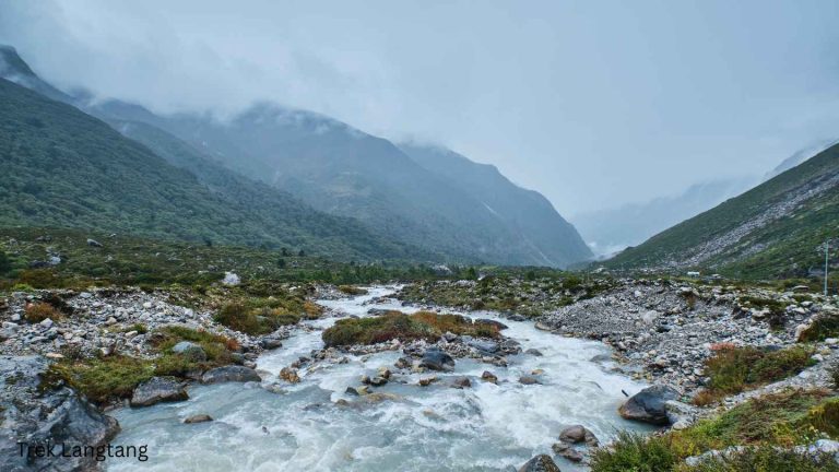
The Langtang Valley is fundamentally a classic U-shaped glacial valley. It was carved by ancient ice flows and is defined by a gradual, relatively gentle altitudinal gradient as it follows the Langtang Khola (river) eastward toward the Tibetan border. The topography is characterized by deep riverine gorges that eventually open up into wide, sweeping alpine pastures surrounded by towering, serrated peaks like Langtang Lirung (7,227m).
Conversely, Gosaikunda is situated on a steep, prominent ridgeline to the south of the Langtang Valley. The trek is an exercise in rapid vertical ascent rather than horizontal valley penetration. The destination is a series of alpine oligotrophic lakes nestled in high-altitude depressions. The topographical profile here is much more dramatic and abrupt, forcing a rapid acclimatization curve as trekkers push straight up the contours of the mountainside.
The Langtang Valley Trek: “The Valley of Glaciers”
The Langtang Valley trek is a journey of steady immersion. It offers a masterclass in Himalayan biodiversity and a deep dive into Tamang and Tibetan heritage.

The Ascending Trail
The trail traditionally begins in Syabrubesi (1,460m) and immediately plunges into dense, sub-tropical forests. As you ascend over the course of three to four days, the micro-environments shift with striking clarity:
- Riverine Deciduous Forests: Dominated by oak, maple, and alder, echoing with the sound of the raging Langtang Khola.
- Temperate Coniferous and Rhododendron Forests: Around Lama Hotel (2,410m), the canopy thickens, offering prime habitat for the elusive red panda and langur monkeys.
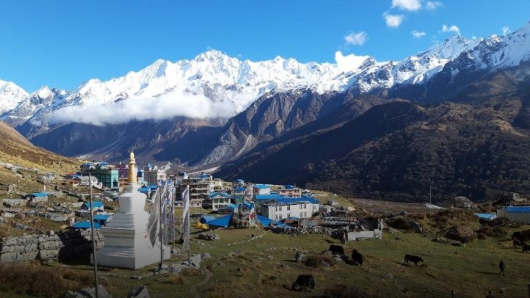
- Alpine Scrub and Pastures: Beyond Langtang Village (3,430m), the tree line breaks. The landscape transitions into hardy alpine scrub, junipers, and vast grazing pastures for yaks.
- Glacial Moraines: At Kyanjin Gompa (3,830m), you are surrounded by the terminal moraines of active glaciers and the looming icefall of Langtang Lirung.
Cultural Tapestry and Resilience
The demographic fabric of the Langtang Valley is predominantly Tamang, a Tibeto-Burman ethnic group whose culture, language, and architectural styles heavily mirror those of neighboring Tibet.
A Note on Resilience: It is impossible to discuss the Langtang Valley without acknowledging the devastating 2015 earthquake, which triggered a massive avalanche that buried the original Langtang Village. Today, trekking this valley is not just a recreational activity; it is an active participation in the region’s economic recovery. The newly rebuilt teahouses stand as a profound testament to human resilience.
Glaciological Highlights
The ultimate reward of this valley is the access it provides to high-altitude viewpoints. Ascending Kyanjin Ri (4,773m) or Tserko Ri (4,984m) offers panoramic, 360-degree vistas of massive glaciers, hanging ice cliffs, and peaks like Dorje Lakpa and Yala Peak. You are not just looking at the mountains; you are standing entirely enveloped within their geological amphitheater.
The Gosaikunda Trek: “The Sacred Alpine Lakes”
While Langtang Valley is horizontal and gradual, the Gosaikunda trek is vertical, abrupt, and steeped in ancient mythology. It is a trail defined by spiritual significance and dramatic altitude gains.
Steepness
Starting from Dhunche (1,960m), the trail wastes no time. It forces an almost immediate, unyielding ascent through steep, root-choked trails.
- Day 1 & 2 (The Forest Ascent): The climb to Sing Gompa (3,330m) is strenuous, characterized by steep switchbacks through dense forests of fir, rhododendron, and hemlock.
- Day 3 (The Alpine Transition): The stretch from Laurebina Yak (3,920m) to the lakes represents a harsh transition into the alpine tundra. The air thins noticeably, and the vegetation disappears, replaced by shattered shale, rocky outcrops, and sweeping views that extend all the way to the Annapurna and Manaslu massifs on clear days.
Hydrology and Mythology
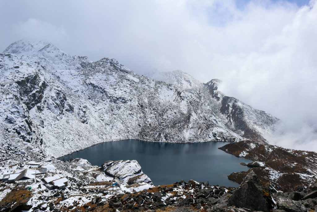
The destination is a complex of over a dozen interconnected high-altitude lakes, the most prominent being Gosaikunda (4,380m). From a hydrological perspective, these lakes are oligotrophic—nutrient-poor, highly oxygenated, and remarkably clear, remaining frozen for six months of the year. They serve as the primary headwaters for the Trishuli River.
From a mythological standpoint, Gosaikunda is a site of immense syncretic reverence. According to Hindu mythology, Lord Shiva created the lake by thrusting his trishul (trident) into the mountain to extract water to cool his burning throat after swallowing poison that threatened to destroy the universe.
During the festival of Janai Purnima (usually in August), the silent, icy shores of Gosaikunda transform. Thousands of Hindu and Buddhist pilgrims, led by traditional Jhankris (shamans) beating rhythmic drums, ascend the mountain to bathe in the holy waters.
Comparative Analysis: A Microsemantic Breakdown
To make an informed decision, we must isolate the specific variables that dictate the lived experience of these two treks.
Acclimatization Gradient and Physical Exertion
- Langtang Valley: The daily altitude gain is generally well within safe physiological limits (approx. 400-600m per day). The trail undulates, allowing the cardiovascular system to adapt gradually. It requires endurance, but the daily physiological stress is moderate.
- Gosaikunda: The ascent from Dhunche to Gosaikunda forces trekkers to gain over 2,400 meters of elevation in just two to three days. This steep gradient significantly increases the statistical probability of Acute Mountain Sickness (AMS). The physical exertion here is highly acute, requiring excellent cardiovascular health and a slow, measured pace.
Scenery: Proximity vs. Panorama
- Langtang Valley: Because you are walking along the valley floor, the mountains loom directly over you. You are at the base of the towering mountains, experiencing the intimidating scale of the icefalls and rock faces up close.
- Gosaikunda: Because you are climbing a prominent ridge, you look out over the landscape rather than up at it. The views from Laurebina Yak offer some of the most expansive horizons in the Nepalese Himalayas, stretching across vast valleys to distant mountain ranges.
Cultural Immersion
- Langtang Valley: Deeply grounded in secular, daily mountain life. You interact with yak herders, observe the intricate masonry of Mani walls (stones carved with Buddhist mantras), visit active Gompas (monasteries), and sample locally produced yak cheese. It is an anthropological observation of Tibetan-Himalayan agricultural life.
- Gosaikunda: Deeply grounded in esoteric and religious practice. While there are teahouses, the overarching atmosphere is defined by pilgrimage and mythology. The shrines, the trident symbols, and the sheer isolation of the lakes give the trek an austere, mystical quality.
Comparison Table: Lantang Trek and Gosaikunda Trek
| Feature | Langtang Valley Trek | Gosaikunda Trek |
|---|---|---|
| Primary Topography | U-shaped Glacial Valley | Steep Alpine Ridgeline |
| Duration (Average) | 7 to 9 Days | 5 to 7 Days |
| Starting Point | Syabrubesi (1,460m) | Dhunche (1,960m) |
| Highest Point | Tserko Ri (4,984m) – Optional | Gosaikunda Lake (4,380m) |
| Sleeping Altitude (Max) | Kyanjin Gompa (3,830m) | Gosaikunda (4,380m) |
| Acclimatization Risk | Low to Moderate (Gradual ascent) | High (Rapid vertical ascent) |
| Cultural Focus | Tamang / Tibetan Daily Life | Hindu / Shamanic Pilgrimage |
| Landscape Highlight | Glaciers, Icefalls, Valley Pastures | Pristine Lakes, Panoramic Ridge Views |
Flora and Fauna: Micro-Habitats
If biodiversity is a primary motivator, Langtang Valley slightly edges out Gosaikunda. Because the valley trail spends more time traversing the lower, wetter riverine and temperate zones before breaking the tree line, it supports a richer density of avifauna (Himalayan monal, blood pheasant) and mammalian life (musk deer, Himalayan tahr). Gosaikunda breaks the tree line much faster, moving quickly into the biologically sparse, albeit visually stunning, alpine tundra.
Culinary and Teahouse Culture
Both treks rely on the standard Nepalese teahouse network, offering staples like Dal Bhat (lentil soup and rice), momos (dumplings), and garlic soup (often consumed as a folk remedy for altitude).
However, Langtang Valley possesses a unique micro-economy centered around dairy. The cheese factory established in Kyanjin Gompa with Swiss assistance in the 1950s means that fresh, aged yak cheese is a dominant culinary feature on this trail, highly recommended for its dense caloric value.
Combining the Two: The Ultimate Langtang Circuit
For trekkers with 12 to 14 days available, the dichotomy does not have to be an either/or choice. The two routes can be elegantly synthesized.
By trekking up the Langtang Valley to Kyanjin Gompa, returning halfway down to the village of “Thulo Syabru,” and then ascending the interconnecting trail up to Sing Gompa and on to Gosaikunda, you achieve the ultimate Himalayan itinerary. This route allows you to utilize the gentle slope of the Langtang Valley to achieve robust acclimatization before tackling the harsh, vertical altitudes of the Gosaikunda lakes, effectively mitigating the primary risk of the latter trek.
Should You Choose Langtang Trek or Gosaikunda Trek?
Choose the Langtang Valley Trek if:
- You prefer a gradual, safer acclimatization profile.
- You want to walk amongst the mountains and get up close to glaciers.
- You are deeply interested in observing Tibetan-influenced village life and post-earthquake recovery.
- You want a slightly longer trek (7-9 days).
Choose the Gosaikunda Trek if:
- You have limited time (5-7 days) and need a highly condensed Himalayan experience.
- You are physically fit enough to handle relentless, steep inclines.
- You prioritize sweeping, panoramic views over close-up glacier encounters.
- You are fascinated by the intersection of dramatic geography and ancient Hindu/Shamanic mythology.
Both trails offer profound physical challenges and stunning aesthetics, but they speak entirely different dialects of the Himalayan language.